Triumph from Tragedy: How a Discovery from the 1974 Super Outbreak Saved Countless Lives
- By Bob Henson
- Mar 25, 2024
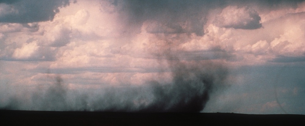
As rain-cooled air descends from a thunderstorm, it can produce damaging winds in excess of hurricane force. These descending winds emerge from a much different process than the updrafts that generate tornadoes. This microburst in the Pawnee National Grasslands of northeast Colorado occurred on 4 September 1982. Dust and debris were picked up and swirled around. A few minutes after this picture was taken, the wind gusted above 50 miles (80 kilometers) per hour. (Photo by Ed Zipser, courtesy NCAR/UCAR Image and Multimedia Gallery)
Like many of you, I’ve found that some weather events – even if they don’t directly affect me – burrow deep into my consciousness and stay lodged there from that point onward. I think this is especially true for major weather disasters that happen when we’re young.
That’s the case for me with the 1974 Super Outbreak, the horrific swarm of tornadoes and severe weather that took more than 300 lives on April 3-4, 1974. I was still in school at this point, but already an avowed weather nerd as well as a budding news junkie, so of course I watched the weather segment on NBC’s “Today” show that morning. In this pre–Al Roker, pre–Willard Scott era, the weather on “Today” was presented über-simply: just a map or two, together with commentary from the stolid news anchor, Frank Blair.
On the morning of April 3, I could tell something was up. Blair’s low-key tone seemed to be just a notch higher, and the map he showed had a huge crosshatched area covering much of the eastern U.S., together with an all-caps label I’d never before seen – something akin to “NUMEROUS SEVERE THUNDERSTORMS”. Which, of course, proved to be both a spot-on forecast and a startling understatement.
I lived in Oklahoma City, well to the west of the outlook area, so I wasn’t personally alarmed. But the news of the eventual outbreak intensified my already keen interest in severe weather.
It took quite a while for scientists to gauge the full scope of the damage produced by the 1974 Super Outbreak. One fateful step in this process was when the eminent tornado researcher Tetsuya Theodore “Ted” Fujita flew over and photographed damage tracks. Today, Fujita is best known as the lead developer of what’s now known as the Enhanced Fujita Scale for assessing tornado damage and rating twisters. But what Fujita discovered in those survey flights a half-century ago ended up transforming aviation safety, and likely saving many thousands of lives.

Theodore "Ted" Fujita was renowned for his meticulous work in observing and analyzing meteorological phenomena, including tornadoes and microbursts, through photographs and damage surveys as well as weather data. (Photo courtesy University of Chicago.)
Fujita had fully expected to see miles and miles of damage along cyclic tracks left by the curlicues of tornado rotation. What he didn’t expect was starburst patterns. These weren’t cycloidal paths, but rather trees felled outward, as if a giant blast dropped from above had knocked them over. Fujita may have been primed to envision such a process: as a young man in the mid-1940s, he’d helped evaluate damage from the massive nuclear bombs dropped on Hiroshima and Nagasaki in his native Japan.
Fujita concluded that about 15% of the 2598 linear miles of damage from what he called the “Jumbo Outbreak” were not produced by tornadoes. He quickly connected the starburst patterns to the downdrafts already known to develop within strong thunderstorms. Before long, he’d dubbed these small but intense versions, spanning just a few miles, “downbursts.” In his 1985 book by the same name, he wrote: “The winds were strong enough to blow down a jet aircraft but were too small to be detected by ground-based anemometers in time for warning approaching aircraft.”
Fujita ended up identifying a more-intense subset, which he named microbursts, defined as spanning less than 4 km (2.5 miles). These were indeed small enough to slip through the cursory observing networks at 1970s airports. So, it was easy to imagine that the microbursts weren’t there, or that they weren’t related to thunderstorms, or they weren’t important in aviation safety.

This schematic shows an airplane landing short of the runway (dotted line) as it encounters the downdraft of a microburst. Note the deviation of the flight path from a normal landing glide path, a result of the changing head winds and the pilot’s reactions. (Image from McCarthy et al., 2022, Addressing the Microburst Threat to Aviation: Research-to-Operations Success Story, BAMS 103, E2845–E2861)
Fujita’s idea didn’t find many takers at first. As he later wrote, “most meteorologists at that time believed that a downdraft, no matter how strong it may be inside or beneath the cloud, should weaken to an insignificant speed long before reaching the surface.”
A series of meticulously designed field projects soon proved Fujita right and the conventional wisdom wrong. So did a simultaneous string of airline tragedies that were eventually linked to microbursts. It’s been so long since a major U.S. aviation disaster that anyone under 40 might be shocked at what transpired over just a few years. For example:
- At New York’s John F. Kennedy International Airport, Eastern Airlines Flight 66 crash-landed a half-mile short of the runway on June 24, 1975, killing 112 of the 124 people on board.
- Pan American Flight 759, taking off from New Orleans International Airport on July 9, 1982, crashed and burned less than 30 seconds after takeoff, killing all 145 people on the plane and 8 in the neighborhood where it went down.
- While attempting to land in an intense thunderstorm at Dallas–Fort Worth International Airport on August 2, 1985, Delta Airlines Flight 191 struck a car on a nearby highway (killing the motorist) and then collided with two water tanks and burst into flame, killing 128 of the 152 passengers on board.

The CLAWS project (Classify, Locate, Avoid Wind Shear) supported development of a prototype system for forecasting microbursts and other wind-shear events and providing timely information to pilots. Here, CLAWS director John McCarthy works in the control tower at Stapleton during CLAWS in the summer of 1984. (Photo © UCAR)
During this same period, Fujita and colleagues at the University of Chicago and the National Science Foundation National Center for Atmospheric Research (NCAR), among others, made the case for the microburst theory with several major field projects: NIMROD (1978, near Chicago), JAWS and CLAWS (1982 and 1984-85, in Denver), and MIST (1986, in Alabama). Each project used Doppler radar together with networks of automated surface stations to map out storm-related winds in and around airports.

Descending air curls outward and upward as it slams into the ground in a microburst near Denver's former Stapleton International Airport on July 6, 1984, during the CLAWS project (Classify, Locate, Avoid Wind Shear). (Photo by Wendy Schreiber-Abshire, © UCAR).
More than 5 million wind observations from the automated weather stations were used to make a first-guess cut at the number of microbursts. Eventually, the scientists concluded there had been 50 in NIMROD and 186 in JAWS.
Results were soon disseminated, and by 1986, the project got covered in the New York Times under the headline “New Clues May Help Pilots Avert Wind Shifts.” Later that decade, NCAR and the MIT Lincoln Laboratory worked with the Federal Aviation Administration to create a dual-pronged warning approach that would use both surface anemometers (low level wind shear alert system) and Doppler radar (Terminal Doppler Weather Radar). The researchers also developed crucial pilot training on microbursts and how to avoid them.
In the 1990s, the newly developed tools were starting to make a huge difference. The microburst-related crash of US Air Flight 1016 near Charlotte killed 37 people on July 2, 1994. But in the nearly three decades since, downbursts have not led to a single death on major U.S. commercial flights.
It’s a stunning success story, one that shows that something good can emerge from even the most horrific weather disaster – and that persistence in science can truly pay off.
PS: I highly recommend the spellbinding documentary “Mr. Tornado”, which aired on the PBS series “American Experience” in 2020. It’s available on Amazon Prime, and clips can be found at the “American Experience” website. For more detail on the research discussed above, see my 2011 article for NCAR & UCAR News, “Tornadoes, Microbursts, and Silver Linings.” And for a much deeper dive on the development of microburst warning and awareness systems, see the 2022 paper in BAMS, "Addressing the Microburst Threat to Aviation: Research-to-Operations Success Story."